The Community Land Model#
The Community Land Model is the land model for the Community Earth System Model (CESM). It focuses on modeling the land as the critical interface through which humanity affects, adapts to, and mitigates global environmental change. It includes a comprehensive representation of land biogeophysics, hydrology, plant physiology, biogeochemistry, anthropogenic land use, and ecosystem dynamics across a variety of spatial and temporal scales. The central theme is that terrestrial ecosystems, through their cycling of energy, water, chemical elements, and trace gases, are important determinants of climate. The model represents several aspects of the land surface including surface heterogeneity and consists of components or submodels related to land biogeophysics, the hydrologic cycle, biogeochemistry, human dimensions, and ecosystem dynamics. Specific processes that are represented include:
Vegetation composition, structure, and phenology
Absorption, reflection, and transmittance of solar radiation
Absorption and emission of longwave radiation
Momentum, sensible heat (ground and canopy), and latent heat (ground evaporation, canopy evaporation, transpiration) fluxes
Heat transfer in soil and snow including phase change
Canopy hydrology (interception, throughfall, and drip)
Snow hydrology (snow accumulation and melt, compaction, water transfer between snow layers)
Soil hydrology (surface runoff, infiltration, redistribution of water within the column, sub-surface drainage, groundwater)
Plant hydrodynamics
Stomatal physiology and photosynthesis
Lake temperatures and fluxes
Dust deposition and fluxes
Routing of runoff from rivers to ocean
Volatile organic compounds emissions
Urban energy balance and climate
Carbon-nitrogen cycling
Dynamic landcover change
Land management including crops and crop management and wood harvest
Ecosystem Demography (FATES, optional)
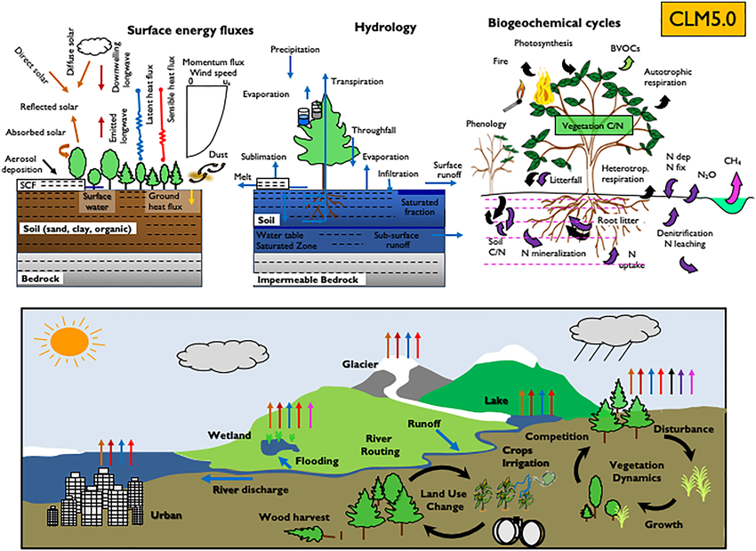
Fig. 1 Overview of land biogeophysical, biogeochemical and landscape processes simulated by CLM5 Lawrence et al. (2019).#
Each time step the model solves the surface energy balance, water balance, and carbon exchange. Submodels of CLM include biophysics and biogeochemistry. It represents land surface heterogeneity through a subgrid tiling structure and different plant functional types that have unique parameters in terms of optical properties, morphology, photosynthesis. It can be run with prescribed vegetation states using satelllite phenology (SP mode) or prognostic vegetation states and biogeochemistry (BGC mode).
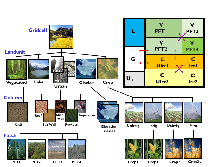
Fig. 2 Configuration of the CLM subgrid hierarchy. Box in upper right shows hypothetical subgrid distribution for a single grid cell. Note that the Crop land unit is only used when the model is run with the crop model active. Abbreviations: TBD – Tall Building District; HD – High Density; MD – Medium Density, G – Glacier, L – Lake, U – Urban, C – Crop, V – Vegetated, PFT – Plant Functional Type, Irr – Irrigated, UIrr – Unirrigated. Red arrows indicate allowed land unit transitions. Purple arrows indicate allowed patch-level transitions. From CLM5 Technical Note.#
More background information on CLM (and it’s latest release CLM5) including documentation and publications can be found here.